The sun glows orange and chaotic in this colorized photo of a solar eruption on May 13, 2025
NASA’s Solar Dynamics Observatory captured this image of a solar flare – seen as the bright flash on the far right – on May 13, 2025. The image shows a subset of extreme ultraviolet light that highlights the extremely hot material in flares and which is colorized in red. Image via NASA/SDO

By Mack Reed

Every satellite – and the service it provides – faces the constant and fast-increasing risk of getting knocked out of service in a collision with other satellites and chunks of orbital debris.

The number of spacecraft, rocket bodies, and debris objects circling earth (estimated at nearly 50,000) has been increasing by an average of 30% per year. 

The National Oceanographic and Atmospheric Administration’s (NOAA) Office of Space Commerce is hurrying development of TRACSS to deliver conjunction warnings and other “basic” SDA services to civilian spacecraft operators. 

But these services can’t address the compounding risks of solar flares – commonly known as “space weather” – which have the potential to deliver an even more powerful blow to thousands of satellites that increasingly prop up life on Earth.

Space weather impacts the performance of GPS, communication, defense, and edge-compute satellite operations, complicating the already-risky orbital environment.

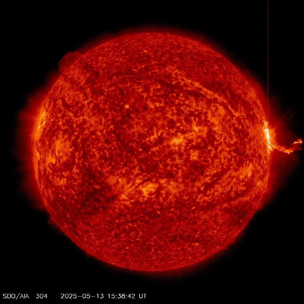
This summer, Earth is entering the peak period of a typical 11-year solar-activity cycle; Solar activity in the form of coronal-mass ejections (CMEs) is sending particle radiation, X-rays and UV radiation towards Earth. On Tuesday, the strongest storm of 2025 – a Class X2.7 flare – hit the earth, knocking out radio signals in Europe, Asia, and the Middle East.

These effects can overwhelm any ability to respond to them adequately because they are felt in Earth’s orbit so quickly – sometimes within tens of minutes after the sun hurled plasma and radiation into space 93 million miles away.

Illustration showing how solar flares generate "space weather" phenomena such as solar flares and coronal mass ejections (CMEs)  cause radiation storms, solar wind, and disturbances in the Earth's magnetic field. Image via https://www.swpc.noaa.gov/phenomena
Illustration of solar phenomena. Click to enlarge. (image via NOAA: via https://www.swpc.noaa.gov/phenomena)

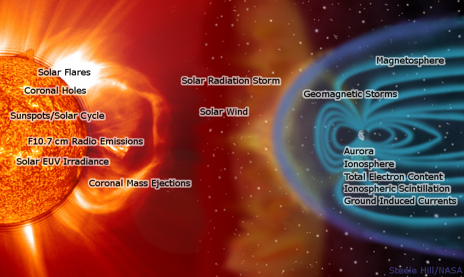
Solar flares disrupts satellite activity in three distinct ways:

  1. SRB (solar radio bursts) are close enough to satellite frequencies that they can interfere with satellite communications and GPS signals
  2. Radiation surges and geomagnetic disruptions from particles flung earthward by CMEs can damage satellite electronics permanently. 
  3. Strong solar activity heats the upper atmosphere, increasing drag on satellites in lower earth orbit (LEO) and making them susceptible to premature deorbit – basically they slow down and fall out of the sky.

The net effects of and risks from solar weather cross many planes of human experience: 

  • GPS inaccuracy: GPS-guided farm equipment can veer off course. GPS disruption throws off pinpoint targeting by several meters for anything from driving directions to weapons deployment.
  • Damage to electrical grids: Though most utility companies are ready for it, and rely on forecasts from NOAA and others to prepare for such events, they can be knocked offline.
  • De-orbit or destabilization: Satellites that we all rely on for communications, edge compute, GPS and other services fall out of orbit due to increased drag or fail to show their true position to operators on earth.

How serious is the drag/de-orbit phenomenon? A surge of space weather last spring threw the problem into sharp relief:

  • In February, 2024, Starlink deployed 49 satellites – and lost 38 of them to drag-induced de-orbiting.
  • In May, 2024, the quintuple solar-flare “Gannon storm” – the largest geomagnetic storm in more than 20 years – caused the “mass migration” of 5,000 satellites (many of them belonging to SpaceX). They moved suddenly – some automatically, some by command – to higher, safer orbits to escape increased drag, forcing them to pass through other orbits and magnifying risk of collision with debris and other spacecraft.
  • The same storm caused SpaceX to suffer position-estimation errors of up to 20 kilometers for their Starlink satellites.
  • As the MIT researcher who reported the effects of those events said at the time: “If we’re uncertain in where our spacecraft are by 20 kilometers, then you can throw collision avoidance out the window.

In all, Kansas State University economics researchers made a “conservative estimate” that the Gannon storm caused $500m in losses to the corn-farming industry alone. So far, there is no estimate of the cost of the ensuing orbits, orbit migrations, and position errors.

How does the risk posed by space weather dovetail with space-domain awareness and national security? Here’s a good summation: 

To prevent collisions in low-Earth orbit, satellite constellation operators have adopted automated collision-avoidance systems.

Unfortunately, the automated systems only work if operators can predict where satellites will be in 12 to 24 hours. But space weather models aren’t that precise.

Forecasts of the arrival time of coronal mass ejections, which increase drag in low Earth orbit, tend to be accurate within 10 hours. As a result, individual satellites can be dozens of kilometers from where operators thought they would be a day earlier.” (Space News 2/12/25)

Green waves of the aurora borealis effect in Earth's upper atmosphere shimmer over a lake at night.
Geomagnetic storms can also trigger surges in the aurora borealis such as the wave of sightings of the phenomenon much farther south on Earth last year than is customarily seen. (Image via NOAA: https://www.swpc.noaa.gov/phenomena/geomagnetic-storms)

This vulnerability is not going unstudied, but the critical examination needed is still in its infancy;  beyond space weather forecasting and shielding electronic components, there is no industrial solution for mitigating the effects of solar flares on the fly. 

U.S. and European weather and space agencies have worked to improve orbital space weather resilience for several decades – but mostly with a preparedness-and-mitigation approach.

NOAA and the European Space Agency maintain weather-monitoring spacecraft at the LaGrange points – positions between Earth and sun where the gravitational forces of both bodies nullify each other – allowing the craft to stay in place and constantly monitor solar winds. 

In May, 2024, a Space Weather Tabletop Exercise (TTX) conducted by NOAA, NASA, NSF, FEMA, DHS, and Johns Hopkins University – the first of its kind – resulted in better planning and coordination among the agencies. The team’s Final Report concluded, “There is a critical need to develop more robust forecasting capabilities of space weather drivers and effects.”

AI and machine learning can be part of that leap forward, empowering a more proactive approach to space weather preparedness and response.  

Built right, by blending space weather into the realm of space domain awareness and daily satellite operations, such technology can de-risk the sun’s short- and long-term effects on earthside services these vital spacecraft sustain.

Watch this space.

 Mack Reed is Head of Product at Planetary Systems AI. He can be reached via our Contact page.

Planetary Systems AI Awarded Second Annual License Subscription by U.S. Space Systems Command’s Space Domain Awareness (SDA) TAP Lab 

From the period of 5 February through 29 April 2025, Planetary Systems AI successfully demonstrated the ability to use generative AI to read large quantities of semi/unstructured text and imagery to populate the Lab’s Target Model Database (TMDB). 

PSAI Awarded Annal 12-Month Subscription License

New York, NY, May 12, 2024Planetary Systems AI (PSAI), a dual-use space and defense tech company accelerating data flow and insight generation for decision-making in the space sector to optimize planetary support operations, announced today that it has been awarded a second annual subscription license by U.S. Space Systems Command’s Space Domain Awareness (SDA) Tools Applications and Processing (TAP) Lab after the completion of the Apollo Accelerator Cohort 6. This program enabled PSAI to demonstrate its capabilities for image-to-text object classification combined with the use of PSAI’s initial subscription license to the SDA TAP Lab – an application using generative AI to read large quantities of semi/unstructured text and imagery to populate the Lab’s Target Model Database (TMDB). The TMDB, once populated with details about a satellite’s payloads, power, and propulsion systems can be used to evaluate potentially threatening close approaches and automated alert system for the Welder’s Arc battle management system. 

“Welder’s Arc is a fully automated, multi-vendor, prototype space threat warning system building partnerships with industry, academia, government, partners, and allies (IAGPA) in the SDA TAP Lab. There have been over 100 companies that have participated in Apollo Accelerator from almost a dozen countries totaling several hundred individuals. Retention is fairly high. We are changing commercial SDA market forces for the better to ensure long term viability of the small business base.” – SDA TAP Lab Chief, Major Sean Allen on the vision of the Apollo Accelerator.

“PSAI is leveraging our multi-modal AI expertise and capabilities to work with the U.S. government, its allies, and our commercial partners to ensure that automated decision support subsystems are accelerated and enhanced through our AI solutions,” said CEO & Chief Space Officer Cindy Chin. “Our CTO Aaron Sloman and Mack Reed on behalf of the team were excited to showcase computer vision experience in an image-to-text capability during the SDA TAP Lab Cohort 6 Demo Day with U.S. Space Systems Command, the U.S. Space Force, U.S. Space Command and other government and industry partners.” 

PSAI will continue to increase space vehicle imagery to its AI model and agentic AI capabilities in its architecture, responding to maneuver alerts in a given scenario related to threat warning and assessment. The current database is structured for direct integration with, query by, and display in SDA tools. PSAI’s APIs and applications can be used with maneuver-event data for inferring potential for threats and determining proximity. Entries were filtered for validity by an AI model trained on Joint Commercial Operations (JCO) Notice to Space Operators records and other trusted analytic sources.

About SDA TAP Lab (https://sdataplab.org/): The Space Domain Awareness TAP Lab accelerates the delivery of space battle management software to operational units. We decompose kill chains, prioritize needs with operators, map needs to technologies, and onboard tech to existing platforms quickly. We partner with industry, academia, and across the government to succeed. 

About Planetary Systems AI (www.planetarysystems.ai): PSAI is a planetary support company accelerating data flow and insight generation for decision-making in the space sector, optimizing planetary support operations.

Planetary Systems AI Press Contact:

Mack Reed
Head of Product
E: pr@planetarysystems.ai

Download a PDF of this Press Release

An application interface showing a satellite photo being analyzed
PSAI demonstrated its AI image analyzer, capable of estimating spacecraft size, mass, equipment, and capabilities.

Last week, PSAI demonstrated our expanded AI toolset for space domain awareness to an audience of military analysts, officers, data scientists, and interested contractors at the SDA TAP Lab’s Demo Day. 

We had capped lab Cohorts 4 and 5 in October and January by showing that our AI and machine-learning methods can generate deeply-detailed capability profiles of thousands of spacecraft from millions of public data records.

Output text from an image analyzing application designed to identify satellite capabilities.
Results from a live test of the image analyzer showing the physical characteristics and capabilities that it estimated after ingesting a photo of a satellite. Click to view this full size.

During Cohort 6 – as shown in last week’s demo – we developed an image analyzer, adding a significant new capability to the lab’s work helping U.S. Space Force Guardians identify and assess unknown, concealed, or hostile spacecraft. 

Our newest tool can ingest a photo of a payload – either from orbit or in a pre-launch clean room – and perform a pixel-by-pixel analysis of its potential capabilities. 

The tool estimates the spacecraft’s size, shape, and mass. It counts and estimates the size of antennas and solar panels. And from these and other visual clues, it can infer onboard capabilities including sensors, cameras, radio equipment and frequencies, and the presence and orientation of thrusters. 

By deploying this tool in their analytical processes, Guardians can gain context for the decisions they must make when interrogating targets for evidence of camouflage, concealment, deception, and maneuvers; What sensors are on board? How powerful might its solar panels, batteries, and thrusters be? Can it take high-resolution photos, jam our radio frequencies, or fire an energy weapon? 

While this tool is in its infancy, we hope to refine and grow its capabilities further when Cohort 7 kicks off later this month. 

Watch this space.